1/15
GB Offline Road Map - OS Based screenshot 0
GB Offline Road Map - OS Based screenshot 1
GB Offline Road Map - OS Based screenshot 2
GB Offline Road Map - OS Based screenshot 3
GB Offline Road Map - OS Based screenshot 4
GB Offline Road Map - OS Based screenshot 5
GB Offline Road Map - OS Based screenshot 6
GB Offline Road Map - OS Based screenshot 7
GB Offline Road Map - OS Based screenshot 8
GB Offline Road Map - OS Based screenshot 9
GB Offline Road Map - OS Based screenshot 10
GB Offline Road Map - OS Based screenshot 11
GB Offline Road Map - OS Based screenshot 12
GB Offline Road Map - OS Based screenshot 13
GB Offline Road Map - OS Based screenshot 14
GB Offline Road Map - OS Based Icon

GB Offline Road Map - OS Based

Andrzej Bieniek
Trustable Ranking IconΈμπιστο
1K+Λήψεις
32MBΜέγεθος
Android Version Icon4.4 - 4.4.4+
Έκδοση Android
2.0.0(21-07-2020)Τελευταία έκδοση
5.0
(1 Αξιολογήσεις)
Age ratingPEGI-3
Λήψη
ΛεπτομέρειεςΑξιολογήσειςΕκδόσειςInfo
1/15

Περιγραφή του GB Offline Road Map - OS Based

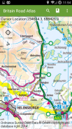
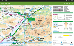
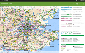
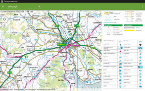
OS (Ordnance Survey) offline map atlas of Great Britain.

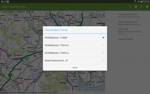
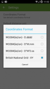
British National Grid coordinates as an option to standard latitude, longitude.

UK Atlas covers England, Wales, Scotland, Orkney, Shetland, Western Isles, Isles of Scilly and Isle of Man. Northern Ireland and the Channel Islands are not covered by this application.


Application provides a regional view of the landscape which is similar in content and appearance to a typical road-atlas.


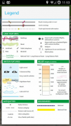
On the map you can browse:

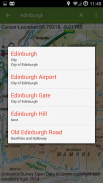
- Cities, towns, villages, centres of population,

- Motorways and junction numbers, A and B roads,

- Railways,

- Rivers,

- Some woodland features and wind farms location.


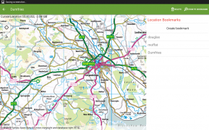
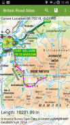
The app is ideal for route planning and geographic context. You can show/follow your current location and calculate distance between points using 'tap' action.


With this app you do not need the paper atlas any more. You will get same level of details - popular OS 1:250K scale and you will be able to check alternative routes just in few seconds.

The application provides support for geographic and British National Grids coordinates - set your default format in settings.

You always know where you are and how to get to your destination.


UK Map Atlas contains 1:50 000 Scale Gazetteer which is a GB reference tool and location finder containing 250,000 distinctive place and feature names.


Contains Ordnance Survey Open Data © Crown copyright and database right 2017.


GB Offline Road Map - OS Based - Έκδοση 2.0.0

(21-07-2020)
Άλλες εκδόσεις
Τι νέο υπάρχειADD: Possibility to copy coordinates to clipboard by clicking the coordinates text view on the map.CHANGE: Updated to ArcGIS SDK 10.2.9 to comply with some Google Policies.FIX: Bookmark selection.

Δεν υπάρχουν ακόμα κριτικές ή βαθμολογίες! Για να αφήσεις την πρώτη,

-
1 Reviews
5
4
3
2
1

GB Offline Road Map - OS Based - Πληροφορίες APK

Έκδοση APK: 2.0.0Πακέτο: com.osedok.britainroadatlas
Συμβατότητα Android: 4.4 - 4.4.4+ (KitKat)
Προγραμματιστής:Andrzej BieniekΔικαιώματα:6
Όνομα: GB Offline Road Map - OS BasedΜέγεθος: 32 MBΛήψεις: 0Έκδοση : 2.0.0Ημερομηνία Κυκλοφορίας: 2021-11-21 18:12:41Ελάχιστη Οθόνη: SMALLΥποστηριζόμενα CPU: x86, armeabi, armeabi-v7a
Αναγνωριστικό Πακέτου: com.osedok.britainroadatlasΥπογραφή SHA1: 72:72:DE:74:E5:41:17:E4:3E:4B:0E:3E:13:9C:42:58:4A:E2:C4:1FΠρογραμματιστής (CN): Andrzej BieniekΟργανισμός (O): Τοποθεσία (L): MotherwellΧώρα (C): GBΠολιτεία/Πόλη (ST): Αναγνωριστικό Πακέτου: com.osedok.britainroadatlasΥπογραφή SHA1: 72:72:DE:74:E5:41:17:E4:3E:4B:0E:3E:13:9C:42:58:4A:E2:C4:1FΠρογραμματιστής (CN): Andrzej BieniekΟργανισμός (O): Τοποθεσία (L): MotherwellΧώρα (C): GBΠολιτεία/Πόλη (ST):

Τελευταία έκδοση του GB Offline Road Map - OS Based

2.0.0Trust Icon Versions
21/7/2020
0 λήψεις32 MB Μέγεθος
Λήψη

Άλλες εκδόσεις

1.6.0Trust Icon Versions
31/12/2015
0 λήψεις24.5 MB Μέγεθος
Λήψη